
Mont Sainte-Odile topographic map
Interactive map
Click on the map to display elevation.
About this map
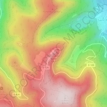
Name: Mont Sainte-Odile topographic map, elevation, terrain.
Average elevation: 599 m
Minimum elevation: 309 m
Maximum elevation: 829 m
Le mont Sainte-Odile (Odilieberri en alsacien, Odilienberg en allemand) est un mont vosgien, situé à Ottrott dans le département du Bas-Rhin, culminant à 767 mètres d'altitude.
Other topographic maps
Click on a map to view its topography, its elevation and its terrain.
Kupferhammer
France > Grand Est > Bas-Rhin > Ottrott
Kupferhammer, Ottrott, Molsheim, Bas-Rhin, Grand Est, France métropolitaine, 67530, France
Average elevation: 343 m