
Thank you for supporting this site ❤️
Make a donation
Make a donation
Råholt topographic map
Click on the map to display elevation.
Thank you for supporting this site ❤️
Make a donation
Make a donation
Råholt
Råholt is a village in the municipality of Eidsvoll, Norway. It is located at an average elevation of 189 meters above the sea level. Its population (2022) is 14,830.
Thank you for supporting this site ❤️
Make a donation
Make a donation
About this map
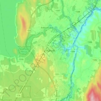
Name: Råholt topographic map, elevation, terrain.
Location: Råholt, Eidsvoll, Viken, 2070, Norway (60.24386 11.13287 60.32386 11.21287)
Average elevation: 189 m
Minimum elevation: 126 m
Maximum elevation: 335 m
Thank you for supporting this site ❤️
Make a donation
Make a donation
Other topographic maps
Click on a map to view its topography, its elevation and its terrain.
Thank you for supporting this site ❤️
Make a donation
Make a donation
Thank you for supporting this site ❤️
Make a donation
Make a donation
Thank you for supporting this site ❤️
Make a donation
Make a donation