
Streversdorp topographic map
Interactive map
Click on the map to display elevation.
About this map
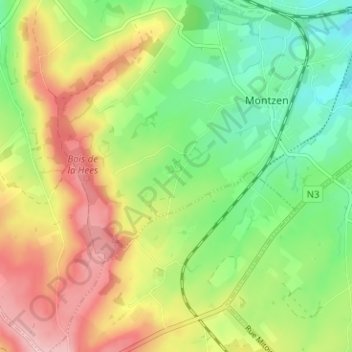
Name: Streversdorp topographic map, elevation, terrain.
Average elevation: 250 m
Minimum elevation: 179 m
Maximum elevation: 340 m
Other topographic maps
Click on a map to view its topography, its elevation and its terrain.
Montzen-Gare
Belgique > Liège > Verviers > Plombières > Montzen-Gare
Montzen-Gare, Plombières, Verviers, Liège, Wallonie, 48750, Belgique
Average elevation: 200 m