
Thank you for supporting this site ❤️
Make a donation
Make a donation
Eton topographic map
Click on the map to display elevation.
Thank you for supporting this site ❤️
Make a donation
Make a donation
About this map
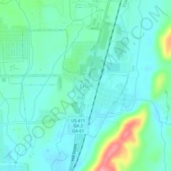
Name: Eton topographic map, elevation, terrain.
Location: Eton, Murray County, Georgia, 30724, United States (34.81084 -84.78047 34.83883 -84.75484)
Average elevation: 236 m
Minimum elevation: 214 m
Maximum elevation: 315 m
Thank you for supporting this site ❤️
Make a donation
Make a donation
Other topographic maps
Click on a map to view its topography, its elevation and its terrain.