
Hitze topographic map
Interactive map
Click on the map to display elevation.
About this map
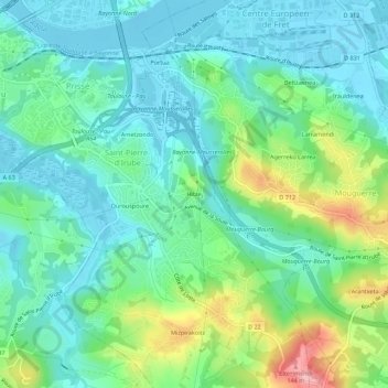
Name: Hitze topographic map, elevation, terrain.
Average elevation: 38 m
Minimum elevation: -2 m
Maximum elevation: 144 m
Other topographic maps
Click on a map to view its topography, its elevation and its terrain.
Mizpirakoïtz
France > Nouvelle-Aquitaine > Pyrénées-Atlantiques > Saint-Pierre-d'Irube > Mizpirakoïtz
Mizpirakoïtz, Saint-Pierre-d'Irube, Bayonne, Pyrénées-Atlantiques, Nouvelle-Aquitaine, France métropolitaine, 64990, France
Average elevation: 54 m