
Thank you for supporting this site ❤️
Make a donation
Make a donation
Atacama Region topographic map
Click on the map to display elevation.
Thank you for supporting this site ❤️
Make a donation
Make a donation
About this map
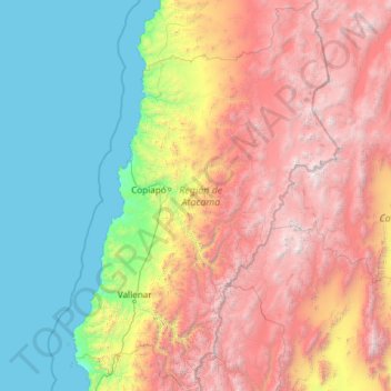
Name: Atacama Region topographic map, elevation, terrain.
Location: Atacama Region, Chile (-29.53472 -71.59253 -25.28684 -68.26321)
Average elevation: 2,011 m
Minimum elevation: 0 m
Maximum elevation: 6,688 m
Thank you for supporting this site ❤️
Make a donation
Make a donation
Other topographic maps
Click on a map to view its topography, its elevation and its terrain.
Villa Cerro Castillo
Chile > Aysén Region > Provincia de General Carrera > Río Ibáñez
Average elevation: 379 m