
Make a donation
Sopuerta topographic map
Click on the map to display elevation.
Make a donation
About this map
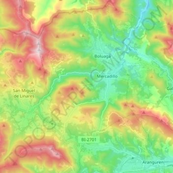
Name: Sopuerta topographic map, elevation, terrain.
Average elevation: 314 m
Minimum elevation: 10 m
Maximum elevation: 788 m
Make a donation
Other topographic maps
Click on a map to view its topography, its elevation and its terrain.
Soil
Spain > Autonomous Community of the Basque Country > Montaña Alavesa/Arabako Mendialdea
Average elevation: 898 m
Unza
Spain > Autonomous Community of the Basque Country > Añanako kuadrilla/Cuadrilla de Añana > Zuhatzu Kuartango
Average elevation: 793 m
Donostia / San Sebastián
Spain > Autonomous Community of the Basque Country > Donostialdea > Donostia / San Sebastián
Average elevation: 134 m
Araotz
Spain > Autonomous Community of the Basque Country > Debagoiena > Oñati > Araotz
Average elevation: 625 m
Make a donation
Hondarribia
Spain > Autonomous Community of the Basque Country > Bidasoa Beherea / Bajo Bidasoa > Hondarribia
Average elevation: 34 m
Zikuñaga
Spain > Autonomous Community of the Basque Country > Donostialdea > Hernani > Zikuñaga
Average elevation: 62 m