
Trujillo topographic map
Interactive map
Click on the map to display elevation.
About this map
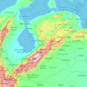
Name: Trujillo topographic map, elevation, terrain.
Location: Trujillo, Venezuela (7.01215 -73.09631 12.13215 -67.97631)
Average elevation: 386 m
Minimum elevation: -5 m
Maximum elevation: 4,619 m
Other topographic maps
Click on a map to view its topography, its elevation and its terrain.
Valera
Venezuela > Trujillo > Municipio Valera
Valera, Parroquia Mercedes Díaz, Municipio Valera, Trujillo, 3101, Venezuela
Average elevation: 1,075 m