
Make a donation
Tampa topographic map
Click on the map to display elevation.
Make a donation
Tampa
Tampa is characterized by a predominantly flat topography, with an average elevation around 16 to 49 feet (5 to 15 meters) above sea level. The terrain is marked by low-lying areas and gentle slopes, with the highest points in the vicinity reaching approximately 62 feet (19 meters). This landscape is interspersed with numerous water bodies, including the expansive Tampa Bay to the west and the Hillsborough River that meanders through the city, contributing to its lush vegetation and diverse ecosystems. The surrounding areas often feature wetlands and marshlands, particularly as one moves toward the coast, creating a rich environment for both wildlife and recreational activities.
Make a donation
About this map
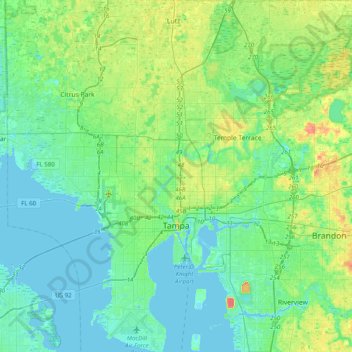
Name: Tampa topographic map, elevation, terrain.
Location: Tampa, Hillsborough County, Florida, United States (27.82126 -82.58650 28.17136 -82.25387)
Average elevation: 11 m
Minimum elevation: -3 m
Maximum elevation: 45 m
Make a donation
Other topographic maps
Click on a map to view its topography, its elevation and its terrain.