
Thank you for supporting this site ❤️
Make a donation
Make a donation
Pulkau topographic map
Click on the map to display elevation.
Thank you for supporting this site ❤️
Make a donation
Make a donation
About this map
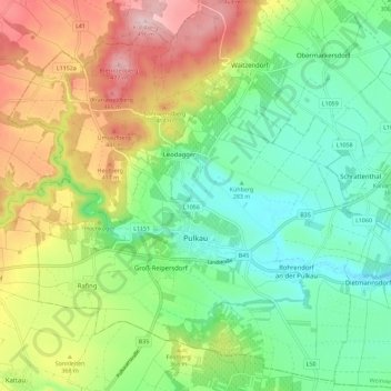
Name: Pulkau topographic map, elevation, terrain.
Average elevation: 329 m
Minimum elevation: 236 m
Maximum elevation: 484 m
Thank you for supporting this site ❤️
Make a donation
Make a donation
Other topographic maps
Click on a map to view its topography, its elevation and its terrain.
Mühlbach am Manhartsberg
Austria > Lower Austria > Bezirk Hollabrunn > Hohenwarth-Mühlbach a.M.
Average elevation: 373 m
Thank you for supporting this site ❤️
Make a donation
Make a donation