
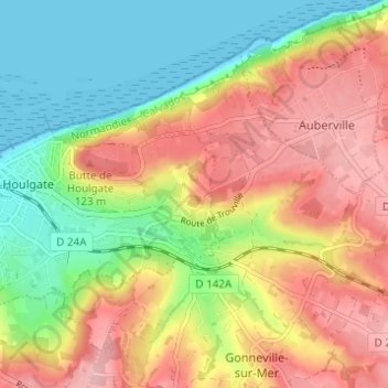
Beuzeval topographic map
Interactive map
Click on the map to display elevation.
About this map
Name: Beuzeval topographic map, elevation, terrain.
Average elevation: 67 m
Minimum elevation: 0 m
Maximum elevation: 137 m
Other topographic maps
Click on a map to view its topography, its elevation and its terrain.
Falaise des vaches noires
France > Normandie > Calvados > Houlgate > Fontaine Pannier
Falaise des vaches noires, Fontaine Pannier, Houlgate, Lisieux, Calvados, Normandie, France métropolitaine, 14640, France
Average elevation: 44 m
Le Lieu Marot
France > Normandie > Calvados > Houlgate
Le Lieu Marot, Houlgate, Lisieux, Calvados, Normandie, France métropolitaine, 14510, France
Average elevation: 36 m
La Cour Ferrey
France > Normandie > Calvados > Houlgate
La Cour Ferrey, Houlgate, Lisieux, Calvados, Normandie, France métropolitaine, 14510, France
Average elevation: 38 m
Fontaine Pannier
France > Normandie > Calvados > Houlgate
Fontaine Pannier, Houlgate, Lisieux, Calvados, Normandie, France métropolitaine, 14510, France
Average elevation: 55 m