
Buch topographic map
Click on the map to display elevation.
About this map
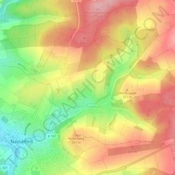
Name: Buch topographic map, elevation, terrain.
Location: Buch, Nastätten, Rhein-Lahn-Kreis, Rhineland-Palatinate, Germany (50.19850 7.85953 50.21818 7.90660)
Average elevation: 329 m
Minimum elevation: 247 m
Maximum elevation: 393 m
Other topographic maps
Click on a map to view its topography, its elevation and its terrain.
Katz Castle
Germany > Rhineland-Palatinate > Rhein-Lahn-Kreis > Sankt Goarshausen > Heide
Average elevation: 178 m
Berghausen
Germany > Rhineland-Palatinate > Rhein-Lahn-Kreis > Berghausen > Berghausen
Average elevation: 336 m