
Thank you for supporting this site ❤️
Make a donation
Make a donation
Camp Springs topographic map
Click on the map to display elevation.
Thank you for supporting this site ❤️
Make a donation
Make a donation
About this map
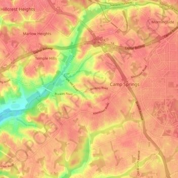
Name: Camp Springs topographic map, elevation, terrain.
Average elevation: 72 m
Minimum elevation: 25 m
Maximum elevation: 90 m
Thank you for supporting this site ❤️
Make a donation
Make a donation
Other topographic maps
Click on a map to view its topography, its elevation and its terrain.
Andrews Manor
United States > Maryland > Prince George's County > Camp Springs
Average elevation: 79 m