
Thank you for supporting this site ❤️
Make a donation
Make a donation
Apúlia topographic map
Click on the map to display elevation.
Thank you for supporting this site ❤️
Make a donation
Make a donation
About this map
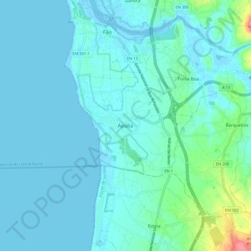
Name: Apúlia topographic map, elevation, terrain.
Location: Apúlia, Esposende, Braga, 4740-069, Portugal (41.44244 -8.80519 41.52244 -8.72519)
Average elevation: 12 m
Minimum elevation: -6 m
Maximum elevation: 95 m
Thank you for supporting this site ❤️
Make a donation
Make a donation
Other topographic maps
Click on a map to view its topography, its elevation and its terrain.