
Thank you for supporting this site ❤️
Make a donation
Make a donation
Warngau topographic map
Click on the map to display elevation.
Thank you for supporting this site ❤️
Make a donation
Make a donation
About this map
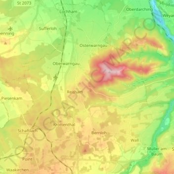
Name: Warngau topographic map, elevation, terrain.
Location: Warngau, Landkreis Miesbach, Baviera, 83627, Germania (47.77024 11.67504 47.86775 11.80141)
Average elevation: 735 m
Minimum elevation: 604 m
Maximum elevation: 901 m
Thank you for supporting this site ❤️
Make a donation
Make a donation
Other topographic maps
Click on a map to view its topography, its elevation and its terrain.