
Littleton topographic map
Click on the map to display elevation.
About this map
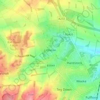
Name: Littleton topographic map, elevation, terrain.
Average elevation: 89 m
Minimum elevation: 43 m
Maximum elevation: 149 m
Other topographic maps
Click on a map to view its topography, its elevation and its terrain.
Dodsley Wood
United Kingdom > England > Hampshire > Winchester > East Stratton
Average elevation: 99 m
Store House Gully
United Kingdom > England > Hampshire > Winchester > Fisher's Pond
Average elevation: 45 m
Beacon Hill Nature Reserve
United Kingdom > England > Hampshire > Winchester > Exton
Average elevation: 128 m
Blackwood Forest
United Kingdom > England > Hampshire > Winchester > East Stratton
Average elevation: 132 m
Old Winchester Hill Iron Age Fort
United Kingdom > England > Hampshire > Winchester
Average elevation: 123 m
Norton Lake
United Kingdom > England > Hampshire > Winchester > Sutton Scotney > Norton
Average elevation: 72 m