
North Cowichan topographic map
Interactive map
Click on the map to display elevation.
About this map
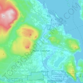
Name: North Cowichan topographic map, elevation, terrain.
Average elevation: 180 m
Minimum elevation: -1 m
Maximum elevation: 1,186 m
Other topographic maps
Click on a map to view its topography, its elevation and its terrain.
Cowichan River
Canada > Colombie-Britannique > Cowichan Valley Regional District > Area F (Cowichan Lake South / Skutz Falls)
Cowichan River, Area F (Cowichan Lake South / Skutz Falls), Cowichan Valley Regional District, Colombie-Britannique, Canada
Average elevation: 196 m