
Thank you for supporting this site ❤️
Make a donation
Make a donation
Halanzy topographic map
Click on the map to display elevation.
Thank you for supporting this site ❤️
Make a donation
Make a donation
About this map
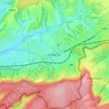
Name: Halanzy topographic map, elevation, terrain.
Location: Halanzy, Aubange, Arlon, Luxembourg, Wallonie, 6792, Belgique (49.53904 5.72225 49.57904 5.76225)
Average elevation: 311 m
Minimum elevation: 244 m
Maximum elevation: 408 m
Thank you for supporting this site ❤️
Make a donation
Make a donation
Other topographic maps
Click on a map to view its topography, its elevation and its terrain.