
Thank you for supporting this site ❤️
Make a donation
Make a donation
1230 topographic map
Click on the map to display elevation.
Thank you for supporting this site ❤️
Make a donation
Make a donation
About this map
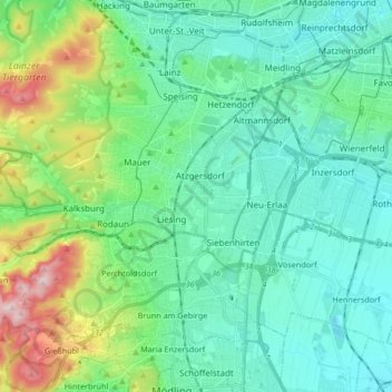
Name: 1230 topographic map, elevation, terrain.
Location: 1230, Liesing, Wien, Vienna, Austria (48.11945 16.20986 48.16271 16.37712)
Average elevation: 256 m
Minimum elevation: 167 m
Maximum elevation: 568 m
Thank you for supporting this site ❤️
Make a donation
Make a donation
Other topographic maps
Click on a map to view its topography, its elevation and its terrain.
Thank you for supporting this site ❤️
Make a donation
Make a donation
Thank you for supporting this site ❤️
Make a donation
Make a donation