
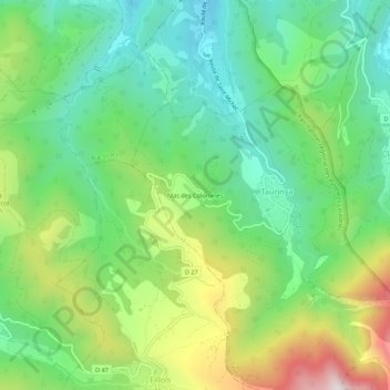
Mas des Colomines topographic map
Interactive map
Click on the map to display elevation.
About this map
Name: Mas des Colomines topographic map, elevation, terrain.
Average elevation: 673 m
Minimum elevation: 408 m
Maximum elevation: 1,182 m
Other topographic maps
Click on a map to view its topography, its elevation and its terrain.
Pic du Canigou
France > Occitanie > Pyrénées-Orientales > Taurinya
Pic du Canigou, Taurinya, Prades, Pyrénées-Orientales, Occitanie, France métropolitaine, 66500, France
Average elevation: 2,353 m
Refuge des Cortalets
France > Occitanie > Pyrénées-Orientales > Taurinya
Refuge des Cortalets, Ancien Chemin de Balaig, Taurinya, Prades, Pyrénées-Orientales, Occitanie, France métropolitaine, 66500, France
Average elevation: 2,070 m