
Make a donation
Loughman topographic map
Click on the map to display elevation.
Make a donation
About this map
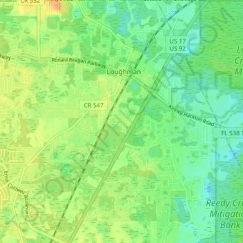
Name: Loughman topographic map, elevation, terrain.
Location: Loughman, Polk County, Florida, United States (28.19961 -81.59057 28.25958 -81.53920)
Average elevation: 32 m
Minimum elevation: 18 m
Maximum elevation: 48 m
Make a donation
Other topographic maps
Click on a map to view its topography, its elevation and its terrain.
Lakeland
United States > Florida > Polk County
Lakeland is characterized by its gently rolling terrain, which is dotted with numerous lakes that contribute to the region's scenic beauty. The area is part of the Central Florida Highlands, with elevations generally ranging from 100 to 250 feet above sea level. The topography is marked by a mix of flatlands…
Average elevation: 44 m
Winter Haven
United States > Florida > Polk County
According to the United States Census Bureau, the city has a total area of 25.4 square miles (66 km2), of which 17.7 square miles (46 km2) is land and 7.7 square miles (20 km2) (30.45%) is water. Winter Haven is located within the Central Florida Highlands area of the Atlantic coastal plain with a terrain…
Average elevation: 40 m
Make a donation
Allen David Broussard Catfish Creek Preserve State Park
United States > Florida > Polk County
Average elevation: 18 m
Winter Haven
United States > Florida > Polk County
According to the United States Census Bureau, the city has a total area of 25.4 square miles (66 km2), of which 17.7 square miles (46 km2) is land and 7.7 square miles (20 km2) (30.45%) is water. Winter Haven is located within the Central Florida Highlands area of the Atlantic coastal plain with a terrain…
Average elevation: 40 m
Make a donation
Fort Meade
United States > Florida > Polk County
Fort Meade is the oldest city in Polk County, dating its origins to 1849 when it was established along a new military road from Tampa (Fort Brooke) to Fort Pierce following the Second Seminole War. The town and road were originally sited by then-lieutenant George Meade of the Corps of Topographical Engineers,…
Average elevation: 39 m
Make a donation
Make a donation
Make a donation
Make a donation
Lake Wales Ridge Wildlife and Environmental Area
United States > Florida > Polk County > Lake Wales
Average elevation: 42 m
Make a donation
Make a donation
Fort Meade
United States > Florida > Polk County
Fort Meade is the oldest city in Polk County, dating its origins to 1849, when it was established along a new military road from Tampa (Fort Brooke) to Fort Pierce following the Second Seminole War. The town and road were originally sited by then-lieutenant George Meade of the Corps of Topographical Engineers,…
Average elevation: 39 m
Make a donation
Make a donation
Winter Haven
United States > Florida > Polk County
According to the United States Census Bureau, the city has a total area of 25.4 square miles (66 km2), of which 17.7 square miles (46 km2) is land and 7.7 square miles (20 km2) (30.45%) is water. Winter Haven is located within the Central Florida Highlands area of the Atlantic coastal plain with a terrain…
Average elevation: 40 m
Make a donation
Fort Meade
United States > Florida > Polk County
Fort Meade is the oldest city in Polk County, dating its origins to 1849 when it was established along a new military road from Tampa (Fort Brooke) to Fort Pierce following the Second Seminole War. The town and road were originally sited by then-lieutenant George Meade of the Corps of Topographical Engineers,…
Average elevation: 39 m
Make a donation
Make a donation