
Saint-Étienne de Gourgas topographic map
Interactive map
Click on the map to display elevation.
About this map
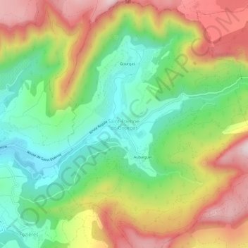
Name: Saint-Étienne de Gourgas topographic map, elevation, terrain.
Average elevation: 447 m
Minimum elevation: 227 m
Maximum elevation: 734 m
Other topographic maps
Click on a map to view its topography, its elevation and its terrain.
Exsurgence du Bacou Supérieure
France > Occitanie > Hérault > Saint-Étienne-de-Gourgas > Saint-Étienne de Gourgas > Gourgas
Exsurgence du Bacou Supérieure, Chemin de Lagardie, Gourgas, Saint-Étienne de Gourgas, Saint-Étienne-de-Gourgas, Lodève, Hérault, Occitanie, France métropolitaine, 34700, France
Average elevation: 534 m