
Make a donation
Sucre topographic map
Click on the map to display elevation.
Make a donation
Sucre
Sucre (Spanish pronunciation: [ˈsukɾe]; Quechua: Chuqichaka; Aymara: Sukri; Guarani: Sucre), officially La Ilustre y Heroica Sucre ("The Illustrious and Heroic Sucre") is the de jure capital city of Bolivia, the capital of the Chuquisaca Department and the sixth most populous city in Bolivia. Located in the south-central part of the country, Sucre lies at an elevation of 2,790 m (9,150 ft), make it the second-highest capital city in the world after Quito. This relatively high altitude gives the city a subtropical highland climate with cool temperatures year-round. Over the centuries, the city has received various names, including La Plata, Charcas, and Chuquisaca. Today, the region is of predominantly Quechua background, with some Aymara communities and influences.
Make a donation
About this map
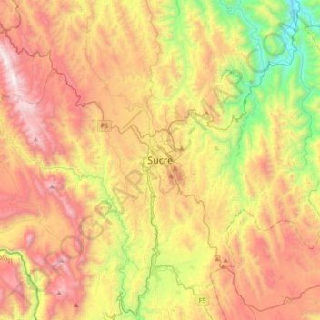
Name: Sucre topographic map, elevation, terrain.
Average elevation: 2,829 m
Minimum elevation: 1,882 m
Maximum elevation: 3,846 m
Make a donation
Other topographic maps
Click on a map to view its topography, its elevation and its terrain.