
Make a donation
Dandenong Ranges topographic map
Click on the map to display elevation.
Make a donation
Dandenong Ranges
The topography consists of a series of ridges dissected by deeply cut streams. Sheltered gullies in the south of the range are home to temperate rain forest, fern gullies and mountain ash forest Eucalyptus regnans, whereas the drier ridges and exposed northern slopes are covered by dry sclerophyll forest of stringybarks and box. The entire range is highly prone to bushfires, the most recent of which have been the 1983 Ash Wednesday bushfires, the 1997 Dandenong Ranges bushfires and small fires during the Black Saturday bushfires in 2009.
Make a donation
About this map
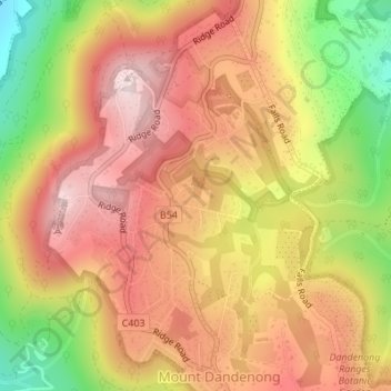
Name: Dandenong Ranges topographic map, elevation, terrain.
Average elevation: 456 m
Minimum elevation: 213 m
Maximum elevation: 621 m
Make a donation
Other topographic maps
Click on a map to view its topography, its elevation and its terrain.
Make a donation
Make a donation
Make a donation
Camberwell
Australia > Victoria > Melbourne
The Prospect Hill Road Precinct area is adjacent to the railway station and is the oldest part of the suburb. The original subdivision was relatively generous blocks, which were quickly filled with fine Victorian and Edwardian houses. Due to its hilly topography, many east–west streets in the Prospect Hill…
Average elevation: 66 m
Make a donation
Make a donation
Make a donation
Make a donation
Make a donation
Make a donation
Make a donation
Make a donation
Make a donation
Make a donation
Healsville Gorge Bushland Reserve
Australia > Victoria > Melbourne > Healesville
Average elevation: 91 m
Make a donation
Make a donation
Make a donation
Make a donation
Make a donation
Camberwell
Australia > Victoria > Melbourne
The Prospect Hill Road Precinct area is adjacent to the railway station and is the oldest part of the suburb. The original subdivision was relatively generous blocks, which were quickly filled with fine Victorian and Edwardian houses. Due to its hilly topography, many east–west streets in the Prospect Hill…
Average elevation: 66 m
Make a donation
Make a donation
Make a donation
Make a donation
Make a donation
Make a donation
Make a donation