
Village of Richfield topographic map
Interactive map
Click on the map to display elevation.
About this map
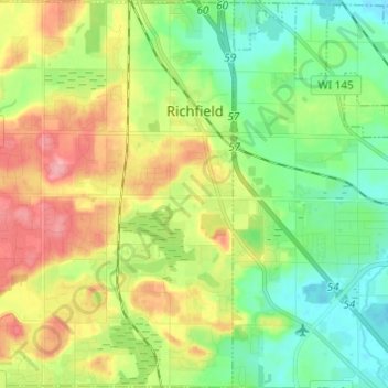
Name: Village of Richfield topographic map, elevation, terrain.
Average elevation: 296 m
Minimum elevation: 254 m
Maximum elevation: 364 m
According to the United States Census Bureau, the village has a total area of 36.46 square miles (94.43 km2), of which, 35.91 square miles (93.01 km2) of it is land and 0.55 square miles (1.42 km2) is water. The low point in the village lies in Section 1 at Little Cedar Creek with an elevation of 856 feet. The high point in the village lies in Section 19 in the Cul-de-sac of Cheyenne Court at an elevation of 1,174 feet. (Washington County, Wi 2foot topography)
Other topographic maps
Click on a map to view its topography, its elevation and its terrain.
West Bend
United States > Wisconsin > Washington County
West Bend, Washington County, Wisconsin, United States
Average elevation: 298 m
Town of Addison
United States > Wisconsin > Washington County
Town of Addison, Washington County, Wisconsin, 53002, United States
Average elevation: 318 m
Town of Polk
United States > Wisconsin > Washington County
Town of Polk, Washington County, Wisconsin, 53086, United States
Average elevation: 305 m
Slinger
United States > Wisconsin > Washington County
Slinger, Washington County, Wisconsin, United States
Average elevation: 331 m
Hartford
United States > Wisconsin > Washington County
Hartford, Washington County, Wisconsin, 53027, United States
Average elevation: 313 m
Village of Germantown
United States > Wisconsin > Washington County
Village of Germantown, Washington County, Wisconsin, United States
Average elevation: 267 m
Allenton
United States > Wisconsin > Washington County > Allenton
Allenton, Washington County, Wisconsin, 53002-9800, United States
Average elevation: 313 m
Kewaskum
United States > Wisconsin > Washington County
Kewaskum, Washington County, Wisconsin, United States
Average elevation: 295 m