
Thank you for supporting this site ❤️
Make a donation
Make a donation
Meerdonk topographic map
Click on the map to display elevation.
Thank you for supporting this site ❤️
Make a donation
Make a donation
Meerdonk
Meerdonk ligt in het gebied van de Wase Scheldepolders. De hoogte bedraagt ongeveer 2,5 meter.
Thank you for supporting this site ❤️
Make a donation
Make a donation
About this map
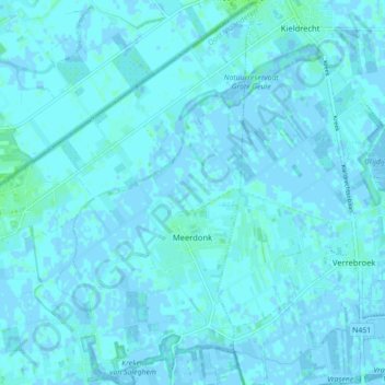
Name: Meerdonk topographic map, elevation, terrain.
Average elevation: 1 m
Minimum elevation: -3 m
Maximum elevation: 7 m
Thank you for supporting this site ❤️
Make a donation
Make a donation
Other topographic maps
Click on a map to view its topography, its elevation and its terrain.
Kwakkel
België > Oost-Vlaanderen > Sint-Niklaas > Sint-Gillis-Waas > Sint-Pauwels
Average elevation: 6 m
Thank you for supporting this site ❤️
Make a donation
Make a donation
Zandloper
België > Oost-Vlaanderen > Sint-Niklaas > Sint-Gillis-Waas > Meerdonk
Average elevation: 1 m