
Thank you for supporting this site ❤️
Make a donation
Make a donation
Gemünd topographic map
Click on the map to display elevation.
Thank you for supporting this site ❤️
Make a donation
Make a donation
Gemünd
Durch den Ort führt der Radwanderweg Eifel-Höhen-Route, der als Rundkurs um und durch den Nationalpark Eifel führt.
Thank you for supporting this site ❤️
Make a donation
Make a donation
About this map
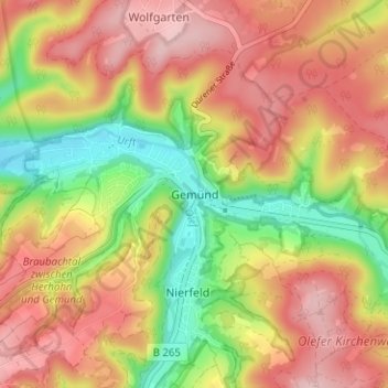
Name: Gemünd topographic map, elevation, terrain.
Average elevation: 436 m
Minimum elevation: 322 m
Maximum elevation: 529 m
Thank you for supporting this site ❤️
Make a donation
Make a donation
Other topographic maps
Click on a map to view its topography, its elevation and its terrain.
53937
Deutschland > Nordrhein-Westfalen > Kreis Euskirchen > Schleiden > Morsbach
Average elevation: 502 m