
Wintzfelden topographic map
Interactive map
Click on the map to display elevation.
About this map
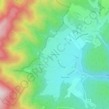
Name: Wintzfelden topographic map, elevation, terrain.
Average elevation: 490 m
Minimum elevation: 286 m
Maximum elevation: 901 m
Other topographic maps
Click on a map to view its topography, its elevation and its terrain.
Le Val du Pâtre
France > Grand Est > Haut-Rhin > Soultzmatt
Le Val du Pâtre, Soultzmatt, Thann-Guebwiller, Haut-Rhin, Grand Est, France métropolitaine, 68570, France
Average elevation: 392 m
Château Wagenbourg
France > Grand Est > Haut-Rhin > Soultzmatt
Château Wagenbourg, Rue de la Vallée, Soultzmatt, Thann-Guebwiller, Haut-Rhin, Grand Est, France métropolitaine, 68570, France
Average elevation: 335 m
Thannwiller
France > Grand Est > Haut-Rhin > Soultzmatt
Thannwiller, Soultzmatt, Thann-Guebwiller, Haut-Rhin, Grand Est, France métropolitaine, 68570, France
Average elevation: 442 m