
Make a donation
Bhimeshwor topographic map
Click on the map to display elevation.
Make a donation
About this map
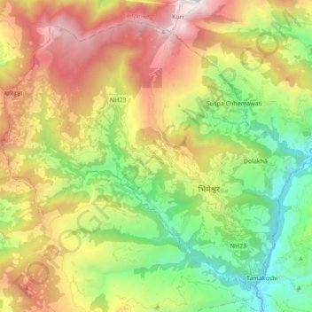
Name: Bhimeshwor topographic map, elevation, terrain.
Location: Bhimeshwor, Dolakha, Bagamati Province, Nepal (27.61307 85.93414 27.74538 86.10600)
Average elevation: 1,992 m
Minimum elevation: 833 m
Maximum elevation: 3,633 m
Make a donation
Other topographic maps
Click on a map to view its topography, its elevation and its terrain.
Make a donation
Make a donation
Tsho Rolpa Lake
Nepal > Bagamati Province > Dolakha
Tsho Rolpa (also Cho Rolpa) is one of the biggest glacial lakes in Nepal. The lake, which is located at an altitude of 4,580 metres (15,030 ft) in the Rolwaling Valley, Dolakha District, has grown considerably over the last 50 years due to glacial melting in the Himalayas.
Average elevation: 4,897 m
Bhimeshwar
Nepal > Bagamati Province > Dolakha
Bhimeshwar, (formerly Charikot), is a municipality in north-eastern Nepal and the headquarters of Dolakha District in Bagmati Province that was established in 1997 by merging the former Village development committees Charikot, Dolakha Town, Makaibari, Mati, Suspaa, and Lankuri danda . At the time of the 2011…
Average elevation: 1,583 m