
La Batie topographic map
Interactive map
Click on the map to display elevation.
About this map
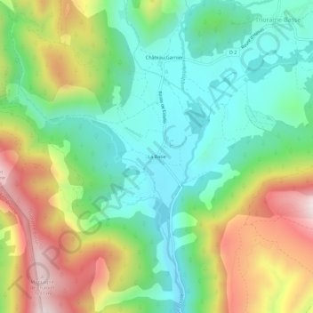
Name: La Batie topographic map, elevation, terrain.
Average elevation: 1,280 m
Minimum elevation: 1,040 m
Maximum elevation: 1,697 m
Other topographic maps
Click on a map to view its topography, its elevation and its terrain.
Le Moustier
France > Provence-Alpes-Côte d'Azur > Alpes-de-Haute-Provence > Thorame-Basse
Le Moustier, Thorame-Basse, Castellane, Alpes-de-Haute-Provence, Provence-Alpes-Côte d'Azur, France métropolitaine, 04170, France
Average elevation: 1,328 m
La Valette
France > Provence-Alpes-Côte d'Azur > Alpes-de-Haute-Provence > Thorame-Basse
La Valette, Thorame-Basse, Castellane, Alpes-de-Haute-Provence, Provence-Alpes-Côte d'Azur, France métropolitaine, 04170, France
Average elevation: 1,644 m
Château-Garnier
France > Provence-Alpes-Côte d'Azur > Alpes-de-Haute-Provence > Thorame-Basse
Château-Garnier, Thorame-Basse, Castellane, Alpes-de-Haute-Provence, Provence-Alpes-Côte d'Azur, France métropolitaine, 04170, France
Average elevation: 1,264 m