
Thank you for supporting this site ❤️
Make a donation
Make a donation
Moosburg topographic map
Click on the map to display elevation.
Thank you for supporting this site ❤️
Make a donation
Make a donation
Moosburg
The oldest town between Regensburg and Italy lies on the river Isar at an altitude of 421 m (1381 ft). It has 20,237 inhabitants (2022) and covers an area of 44 km2. It is easily reached by the A 92 autobahn and regional trains on the Munich–Regensburg line. Furthermore, it takes just 20 minutes to get to Munich Airport.
Thank you for supporting this site ❤️
Make a donation
Make a donation
About this map
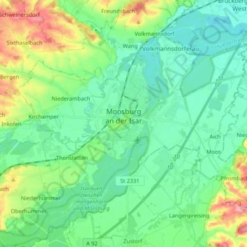
Name: Moosburg topographic map, elevation, terrain.
Location: Moosburg, Landkreis Freising, Bavaria, 85368, Germany (48.42698 11.86724 48.49993 12.01942)
Average elevation: 428 m
Minimum elevation: 397 m
Maximum elevation: 513 m
Thank you for supporting this site ❤️
Make a donation
Make a donation
Other topographic maps
Click on a map to view its topography, its elevation and its terrain.