
Casal Sancho topographic map
Interactive map
Click on the map to display elevation.
About this map
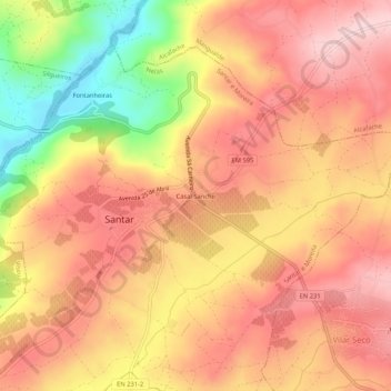
Name: Casal Sancho topographic map, elevation, terrain.
Location: Casal Sancho, Santar e Moreira, Nelas, Viseu, Portugal (40.55323 -7.90559 40.59323 -7.86559)
Average elevation: 355 m
Minimum elevation: 206 m
Maximum elevation: 439 m
Other topographic maps
Click on a map to view its topography, its elevation and its terrain.
Carvalhal Redondo
Carvalhal Redondo, Nelas, Viseu, 3525-075, Portugal
Average elevation: 375 m
Lapa do Lobo
Lapa do Lobo, Nelas, Viseu, 3525-642, Portugal
Average elevation: 312 m