
Thank you for supporting this site ❤️
Make a donation
Make a donation
Syracuse topographic map
Click on the map to display elevation.
Thank you for supporting this site ❤️
Make a donation
Make a donation
About this map
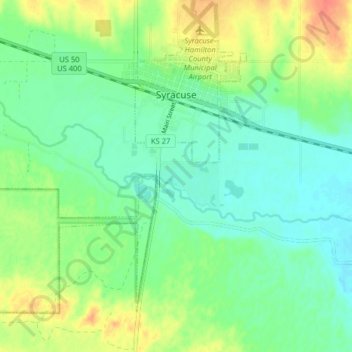
Name: Syracuse topographic map, elevation, terrain.
Location: Syracuse, Hamilton County, Kansas, 67878, United States (37.94127 -101.81678 37.99049 -101.73671)
Average elevation: 992 m
Minimum elevation: 975 m
Maximum elevation: 1,021 m
Thank you for supporting this site ❤️
Make a donation
Make a donation
Other topographic maps
Click on a map to view its topography, its elevation and its terrain.