
Thank you for supporting this site ❤️
Make a donation
Make a donation
Cookeville topographic map
Click on the map to display elevation.
Thank you for supporting this site ❤️
Make a donation
Make a donation
Cookeville
Located on the Highland Rim, Cookeville's elevation (1100 ft AMSL) is a few hundred feet higher than either Nashville or Knoxville. As a result, temperatures and humidity levels are generally slightly lower in Cookeville than in either the Nashville Basin or in the Tennessee Valley.
Thank you for supporting this site ❤️
Make a donation
Make a donation
About this map
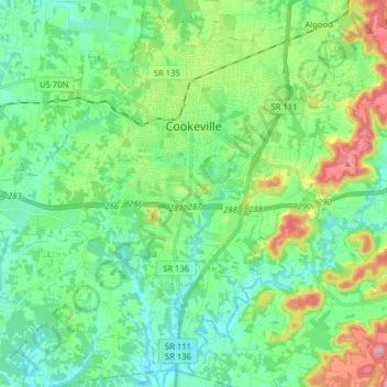
Name: Cookeville topographic map, elevation, terrain.
Average elevation: 332 m
Minimum elevation: 276 m
Maximum elevation: 483 m
Thank you for supporting this site ❤️
Make a donation
Make a donation