
Thank you for supporting this site ❤️
Make a donation
Make a donation
Aleppo Governorate topographic map
Click on the map to display elevation.
Thank you for supporting this site ❤️
Make a donation
Make a donation
Aleppo Governorate
The average elevation of the terrain is 379 metres (1,243 ft). The surface gradually slopes down in north-south and west-east directions, undulating gently with an amplitude of 10–30 m for each wave. The lowlands are covered with combined Paleozoic and Mesozoic sediments that average 4–5 km in thickness over the whole surface.
Thank you for supporting this site ❤️
Make a donation
Make a donation
About this map
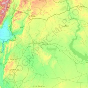
Name: Aleppo Governorate topographic map, elevation, terrain.
Location: Aleppo Governorate, Syria (35.38381 36.54368 36.92412 38.72058)
Average elevation: 439 m
Minimum elevation: 77 m
Maximum elevation: 2,182 m
Thank you for supporting this site ❤️
Make a donation
Make a donation
Other topographic maps
Click on a map to view its topography, its elevation and its terrain.