
Sulur topographic map
Interactive map
Click on the map to display elevation.
About this map
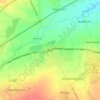
Name: Sulur topographic map, elevation, terrain.
Location: Sulur, Coimbatore District, Tamil Nadu, 641402, India (10.98689 77.08586 11.06689 77.16586)
Average elevation: 371 m
Minimum elevation: 343 m
Maximum elevation: 405 m
Sulur is located at 11°01′31″N 77°07′29″E / 11.0254°N 77.1246°E / 11.0254; 77.1246. It has an average elevation of 340 metres (1115 feet). Sulur is regarded as a pleasant town situated very close to the cities of Coimbatore "Manchester of South India" (19 km) and Tirupur (35 km). Thus it is a popular location for various textile mills and weaving slots. Near to Sulur there is a railway station and an Air Force base. The twin lakes to the north of the town, bounding the Coimbatore-Nagapattinam highway adds a scenic view to the town. The town is divided into two parts by the holy Noyyal River. Sulur is the East-end of the new Coimbatore district.
Other topographic maps
Click on a map to view its topography, its elevation and its terrain.
Somanur
India > Tamil Nadu > Sulur
Somanur, Sulur, Coimbatore District, Tamil Nadu, 641668, India
Average elevation: 346 m
Kaduvettipalayam
India > Tamil Nadu > Sulur
Kaduvettipalayam, Sulur, Coimbatore District, Tamil Nadu, 641659, India
Average elevation: 366 m
Pallapalayam - Kannampalayam Canal
India > Tamil Nadu > Sulur
Pallapalayam - Kannampalayam Canal, Papampatti Pirivu, Sulur, Coimbatore District, Tamil Nadu, 641402, India
Average elevation: 381 m
Noyyal River
India > Tamil Nadu > Sulur
Noyyal River, Papampatti Pirivu, Sulur, Coimbatore District, Tamil Nadu, India
Average elevation: 376 m
Senjerimalai
India > Tamil Nadu > Sulur > Senjerimalai
Senjerimalai, Sulur, Coimbatore District, Tamil Nadu, India
Average elevation: 372 m
Peedampalli
India > Tamil Nadu > Sulur
Peedampalli, Sulur, Coimbatore District, Tamil Nadu, 641016, India
Average elevation: 398 m
Kalangal
India > Tamil Nadu > Sulur
Kalangal, Sulur, Coimbatore District, Tamil Nadu, 641402, India
Average elevation: 388 m