
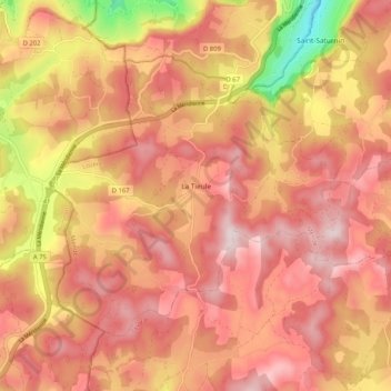
La Tieule topographic map
Interactive map
Click on the map to display elevation.
About this map
Name: La Tieule topographic map, elevation, terrain.
Average elevation: 872 m
Minimum elevation: 593 m
Maximum elevation: 1,015 m
Other topographic maps
Click on a map to view its topography, its elevation and its terrain.
Saint-Étienne-Vallée-Française
Saint-Étienne-Vallée-Française, Florac, Lozère, Occitania, Metropolitan France, 48330, France
Average elevation: 477 m
Thonas
France > Occitania > Lozère > Saint-Germain-de-Calberte
Thonas, Saint-Germain-de-Calberte, Florac, Lozère, Occitania, Metropolitan France, 48370, France
Average elevation: 463 m
Le Collet-de-Dèze
France > Occitania > Lozère > Le Collet-de-Dèze
Le Collet-de-Dèze, Florac, Lozère, Occitania, Metropolitan France, 48160, France
Average elevation: 516 m
Laval-Atger
France > Occitania > Lozère > Saint Bonnet-Laval
Laval-Atger, Saint Bonnet-Laval, Mende, Lozère, Occitania, Metropolitan France, 48600, France
Average elevation: 987 m
Condres
France > Occitania > Lozère > Saint Bonnet-Laval
Condres, Saint-Bonnet-de-Montauroux, Saint Bonnet-Laval, Mende, Lozère, Occitania, Metropolitan France, 48600, France
Average elevation: 888 m