
Thank you for supporting this site ❤️
Make a donation
Make a donation
Noss Head topographic map
Click on the map to display elevation.
Thank you for supporting this site ❤️
Make a donation
Make a donation
About this map
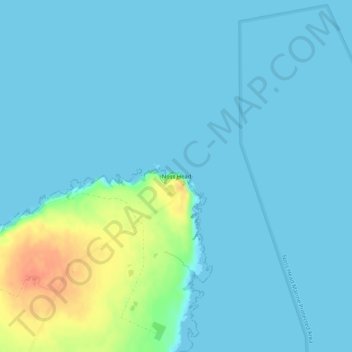
Name: Noss Head topographic map, elevation, terrain.
Location: Noss Head, Caithness, Scotland, KW1 4QT, United Kingdom (58.47937 -3.05231 58.47947 -3.05221)
Average elevation: 7 m
Minimum elevation: 0 m
Maximum elevation: 45 m
Thank you for supporting this site ❤️
Make a donation
Make a donation
Other topographic maps
Click on a map to view its topography, its elevation and its terrain.