
Stadt Hohenems topographic map
Interactive map
Click on the map to display elevation.
Stadt Hohenems
The town is located at 432 metres (1,417 feet) above sea level, about 16 km (10 miles) south of Lake Constance. Hohenems extends for 5.5 km (3.4 mi) from north to south and 8.2 km (5.1 mi) from west to east. Its total area is 29 square kilometres (11 sq mi), of which 42% is covered with forest. The oxbow lake of the river Rhine in the west, forming the border of Austria as well as EU to Switzerland, and the mountainside in the east is at the narrowest point of the Austrian Rhine valley. The Schlossberg ("castle mountain"), elevation 740 metres (2,428 feet), offers a distinctive backdrop to the town center.
About this map
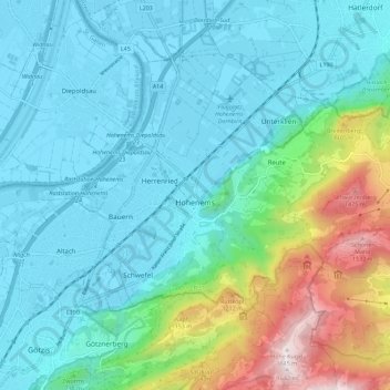
Name: Stadt Hohenems topographic map, elevation, terrain.
Location: Stadt Hohenems, Bezirk Dornbirn, Vorarlberg, 6845, Austria (47.33757 9.64955 47.39322 9.76241)
Average elevation: 660 m
Minimum elevation: 402 m
Maximum elevation: 1,636 m