
Thank you for supporting this site ❤️
Make a donation
Make a donation
Quatre Bornes topographic map
Click on the map to display elevation.
Thank you for supporting this site ❤️
Make a donation
Make a donation
About this map
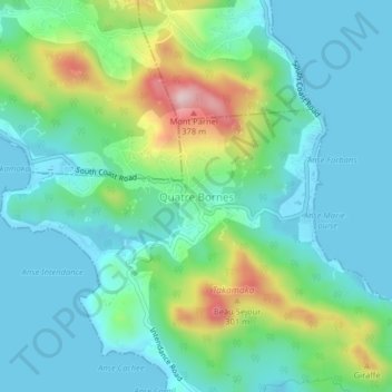
Name: Quatre Bornes topographic map, elevation, terrain.
Location: Quatre Bornes, Takamaka, Seychelles (-4.79908 55.49157 -4.75908 55.53157)
Average elevation: 91 m
Minimum elevation: -1 m
Maximum elevation: 372 m
Thank you for supporting this site ❤️
Make a donation
Make a donation