
Mocha topographic map
Interactive map
Click on the map to display elevation.
About this map
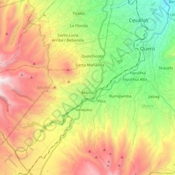
Name: Mocha topographic map, elevation, terrain.
Location: Mocha, Cantón Mocha, Tungurahua, Équateur (-1.47127 -78.76872 -1.35775 -78.61414)
Average elevation: 3,488 m
Minimum elevation: 2,676 m
Maximum elevation: 4,511 m
Other topographic maps
Click on a map to view its topography, its elevation and its terrain.
Carihuairazo
Équateur > Tungurahua > Mocha
Carihuairazo, Mocha, Cantón Mocha, Tungurahua, Équateur
Average elevation: 4,572 m