
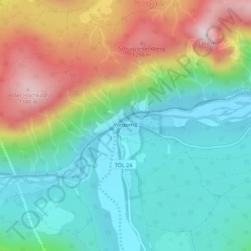
Vorderriß topographic map
Interactive map
Click on the map to display elevation.
About this map
Name: Vorderriß topographic map, elevation, terrain.
Average elevation: 971 m
Minimum elevation: 773 m
Maximum elevation: 1,354 m
Other topographic maps
Click on a map to view its topography, its elevation and its terrain.
Hohenwiesen
Deutschland > Bayern > Landkreis Bad Tölz-Wolfratshausen > Lenggries
Hohenwiesen, Lenggries, Landkreis Bad Tölz-Wolfratshausen, Bayern, Deutschland
Average elevation: 858 m
Untermurbach
Deutschland > Bayern > Landkreis Bad Tölz-Wolfratshausen > Lenggries > Wegscheid
Untermurbach, Wegscheid, Lenggries, Landkreis Bad Tölz-Wolfratshausen, Bayern, 83661, Deutschland
Average elevation: 753 m
Sylvensteinspeicher
Deutschland > Bayern > Landkreis Bad Tölz-Wolfratshausen > Lenggries > Fall
Sylvensteinspeicher, Fall, Lenggries, Landkreis Bad Tölz-Wolfratshausen, Bayern, Deutschland
Average elevation: 955 m
Hochalm
Deutschland > Bayern > Landkreis Bad Tölz-Wolfratshausen > Lenggries
Hochalm, Lenggries, Landkreis Bad Tölz-Wolfratshausen, Bayern, Deutschland
Average elevation: 1,085 m