
Thank you for supporting this site ❤️
Make a donation
Make a donation
Waitsfield topographic map
Click on the map to display elevation.
Thank you for supporting this site ❤️
Make a donation
Make a donation
About this map
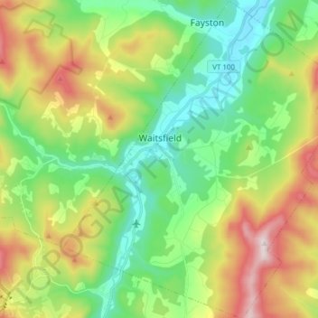
Name: Waitsfield topographic map, elevation, terrain.
Location: Waitsfield, Washington County, Vermont, United States (44.13026 -72.86871 44.23957 -72.73779)
Average elevation: 424 m
Minimum elevation: 185 m
Maximum elevation: 869 m
Thank you for supporting this site ❤️
Make a donation
Make a donation
Other topographic maps
Click on a map to view its topography, its elevation and its terrain.
Thank you for supporting this site ❤️
Make a donation
Make a donation
North Montpelier
United States > Vermont > Washington County > East Montpelier
Average elevation: 278 m