
鼓浪屿 topographic map
Interactive map
Click on the map to display elevation.
About this map
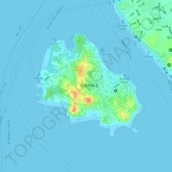
Name: 鼓浪屿 topographic map, elevation, terrain.
Location: 鼓浪屿, 鼓浪屿街道, 思明区, 厦门市, 福建省, 中国 (24.43839 118.05294 24.45610 118.07199)
Average elevation: 5 m
Minimum elevation: -1 m
Maximum elevation: 52 m
面积1.77平方千米,与厦门市区相隔不到1,000米。最高海拔92.7米(日光岩顶)。