
Hilden topographic map
Interactive map
Click on the map to display elevation.
About this map
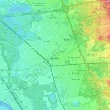
Name: Hilden topographic map, elevation, terrain.
Location: Hilden, Kreis Mettmann, North Rhine-Westphalia, Germany (51.14050 6.89076 51.19797 6.98635)
Average elevation: 55 m
Minimum elevation: 34 m
Maximum elevation: 109 m
Other topographic maps
Click on a map to view its topography, its elevation and its terrain.
Neviges
Germany > North Rhine-Westphalia > Kreis Mettmann
Neviges, Velbert, Kreis Mettmann, North Rhine-Westphalia, 42553, Germany
Average elevation: 212 m
Langenfeld (Rheinland)
Germany > North Rhine-Westphalia > Kreis Mettmann > Langenfeld (Rheinland)
Langenfeld (Rheinland), Kreis Mettmann, North Rhine-Westphalia, 40764, Germany
Average elevation: 55 m
Velbert
Germany > North Rhine-Westphalia > Kreis Mettmann
Velbert, Kreis Mettmann, North Rhine-Westphalia, Germany
Average elevation: 172 m