
Otranto topographic map
Interactive map
Click on the map to display elevation.
About this map
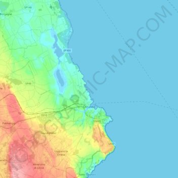
Name: Otranto topographic map, elevation, terrain.
Location: Otranto, Lecce, Pouilles, 73028, Italie (40.07660 18.39312 40.25432 18.52051)
Average elevation: 25 m
Minimum elevation: -4 m
Maximum elevation: 130 m
Other topographic maps
Click on a map to view its topography, its elevation and its terrain.
Baia dei Turchi
Italie > Pouilles > Lecce > Otranto
Baia dei Turchi, Otranto, Lecce, Pouilles, Italie
Average elevation: 4 m
Presicce-Acquarica
Presicce-Acquarica, Lecce, Pouilles, Italie
Average elevation: 123 m