Geolocate

Pine Township topographic map

Interactive map

Click on the map to display elevation.

About this map

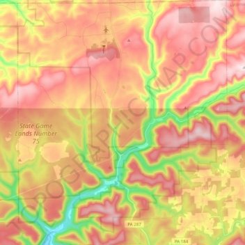
Name: Pine Township topographic map, elevation, terrain.

Location: Pine Township, Lycoming County, Pennsylvania, 16938, United States (41.39912 -77.35989 41.54578 -77.19166)

Average elevation: 493 m

Minimum elevation: 235 m

Maximum elevation: 680 m

The villages of Oregon Hill and English Center were founded by survivors of the failed English Settlement. Oregon Hill, at an elevation of 1,700 feet (520 m) in the northern part of the township, was the location of two churches, a blacksmith shop, and two stores along with several homes. The settlers of Oregon Hill were surprised to find that the land in the area was fertile unlike much of the surrounding land. English Center on Little Pine Creek was a milling town.

Wikipedia (CC-BY-SA 3.0)

Other topographic maps

Click on a map to view its topography, its elevation and its terrain.

Williamsport

United States > Pennsylvania > Lycoming County

Williamsport, Lycoming County, Pennsylvania, United States

Average elevation: 253 m

Chippewa

United States > Pennsylvania > Lycoming County > Muncy Township

Chippewa, Muncy Township, Lycoming County, Pennsylvania, 17756, United States

Average elevation: 175 m

Little Pine Creek

United States > Pennsylvania > Lycoming County > Pine Township

Little Pine Creek, Pine Township, Lycoming County, Pennsylvania, United States

Average elevation: 436 m

English Center

United States > Pennsylvania > Lycoming County > Pine Township

English Center, Pine Township, Lycoming County, Pennsylvania, United States

Average elevation: 444 m

Montoursville

United States > Pennsylvania > Lycoming County

Montoursville, Lycoming County, Pennsylvania, United States

Average elevation: 171 m

Anthony Township

United States > Pennsylvania > Lycoming County

Anthony Township, Lycoming County, Pennsylvania, 17746, United States

Average elevation: 326 m

Mifflin Township

United States > Pennsylvania > Lycoming County

Mifflin Township, Lycoming County, Pennsylvania, United States

Average elevation: 377 m

Warrensville

United States > Pennsylvania > Lycoming County

Warrensville, Lycoming County, Pennsylvania, United States

Average elevation: 277 m

South Williamsport

United States > Pennsylvania > Lycoming County

South Williamsport, Lycoming County, Pennsylvania, United States

Average elevation: 221 m

Heshbon Park

United States > Pennsylvania > Lycoming County

Heshbon Park, Lycoming County, Pennsylvania, 17728, United States

Average elevation: 235 m

Steam Valley

United States > Pennsylvania > Lycoming County

Steam Valley, Lycoming County, Pennsylvania, United States

Average elevation: 539 m

Trout Run

United States > Pennsylvania > Lycoming County

Trout Run, Lycoming County, Pennsylvania, 17771, United States

Average elevation: 471 m

Hughesville

United States > Pennsylvania > Lycoming County > Hughesville

Hughesville, Lycoming County, Pennsylvania, United States

Average elevation: 182 m

Muncy

United States > Pennsylvania > Lycoming County

Muncy, Lycoming County, Pennsylvania, United States

Average elevation: 159 m

Waterville

United States > Pennsylvania > Lycoming County

Waterville, Lycoming County, Pennsylvania, United States

Average elevation: 390 m

Balls Mills

United States > Pennsylvania > Lycoming County > Balls Mills

Balls Mills, Lycoming County, Pennsylvania, 17728, United States

Average elevation: 272 m

Elk Knob

United States > Pennsylvania > Lycoming County

Elk Knob, Lycoming County, Pennsylvania, 17771, United States

Average elevation: 526 m

Coal Mountain

United States > Pennsylvania > Lycoming County

Coal Mountain, Lycoming County, Pennsylvania, United States

Average elevation: 482 m