
La Verrerie topographic map
Interactive map
Click on the map to display elevation.
About this map
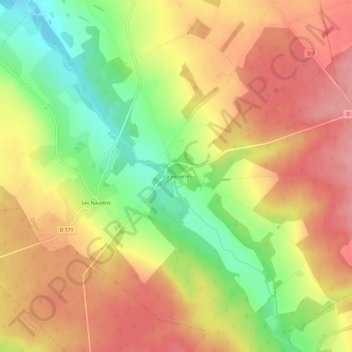
Name: La Verrerie topographic map, elevation, terrain.
Average elevation: 275 m
Minimum elevation: 211 m
Maximum elevation: 323 m
Other topographic maps
Click on a map to view its topography, its elevation and its terrain.
Les Naudins
France > Centre-Val de Loire > Cher > Oizon
Les Naudins, Oizon, Vierzon, Cher, Centre-Val de Loire, France métropolitaine, 18700, France
Average elevation: 270 m
Les Marats
France > Centre-Val de Loire > Cher > Oizon > La Verrerie
Les Marats, La Verrerie, Oizon, Vierzon, Cher, Centre-Val de Loire, France métropolitaine, 18700, France
Average elevation: 273 m