
Thank you for supporting this site ❤️
Make a donation
Make a donation
Carrega Ligure topographic map
Click on the map to display elevation.
Thank you for supporting this site ❤️
Make a donation
Make a donation
About this map
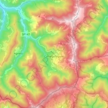
Name: Carrega Ligure topographic map, elevation, terrain.
Location: Carrega Ligure, Alessandria, Piedmont, Italy (44.57355 9.10216 44.66828 9.20524)
Average elevation: 1,080 m
Minimum elevation: 501 m
Maximum elevation: 1,660 m
Thank you for supporting this site ❤️
Make a donation
Make a donation
Other topographic maps
Click on a map to view its topography, its elevation and its terrain.
Thank you for supporting this site ❤️
Make a donation
Make a donation
Thank you for supporting this site ❤️
Make a donation
Make a donation