
Thank you for supporting this site ❤️
Make a donation
Make a donation
Calvi dell'Umbria topographic map
Click on the map to display elevation.
Thank you for supporting this site ❤️
Make a donation
Make a donation
About this map
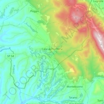
Name: Calvi dell'Umbria topographic map, elevation, terrain.
Location: Calvi dell'Umbria, Terni, Umbria, 05032, Italy (42.36478 12.47916 42.43519 12.61560)
Average elevation: 355 m
Minimum elevation: 76 m
Maximum elevation: 1,109 m
Thank you for supporting this site ❤️
Make a donation
Make a donation
Other topographic maps
Click on a map to view its topography, its elevation and its terrain.